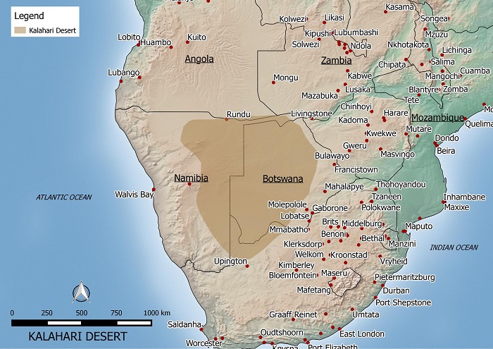
Environmental Maps Enviro-Map.com

Environmental Maps from around the World

Victoria Australia Bushfire Map

Posted by enviro On February - 12 - 2009

Victoria bushfire map

The map above shows the approximate areas in Victoria affected by bushfire in February 2009. Authorities believe the fires were lit deliberately and are currently searching for the arsonists. The death toll in Victoria is expected to run into the hundreds. The major areas affected are located around Melbourne especially the towns of Marysville, Buxton and Narbethong. Residents have lost their houses, livestock and their livelhoods.

Salar de Uyuni Bolivia’s Salt Desert

Posted by enviro On February - 3 - 2009

Salar de Uyuni in Bolivia

The Saral de Uyuni located in Bolivia is the worlds largest salt flat. It is located in the southwest of Bolivia and is about 10,582 km². The salt flat used to be part of a large prehistoric lake named Lake Minchin that existed approximately 40,000 years ago.

Salar de Uyuni salt desert

Annually 25,000 tons of salt is extracted from the region. Lithium reserves can also be found in the region, but so far there are no mining sites. Other important uses for the region include tourism and the breeding of South American flamingos.

Here is a picture of the flat surface of the Salar de Uyuni. This photo is by Luís H. R. Mota and referenced from wikipedia.

The Gaza Strip Location Map

Posted by enviro On January - 19 - 2009

Gaza Strip Location Map

Here is a political map showing the location of the Gaza Strip in relation to Israel and nearby countries. The region is not recognized internationally as apart of any sovereign country but it is claimed as a part of Palestinian Territories. Despite this, Israel still maintains military control over its land borders, airspace and territorial borders.

The Gaza Strip is home to about 1.4 million people most of which are Sunni Muslims. A small percentage of the population is made up of Christians. The region has temperate climate with mild winters and hot dry summers. The Gaza Strip is sometimes subject to drought and significant environmental issues include the salination of its fresh water supply and desertification.

Australia’s Precious Forests

Posted by enviro On September - 22 - 2008

Australian Forest Map

Here is a map showing the general location of Australia’s tropical and temperate forests.

Australia’s forests face many threats including habitat modification, impact of exotic species, altered fire regimes, ecologically unsustainable resource use, and climate change.

Major Australian Deserts

Posted by enviro On September - 16 - 2008

Australian Desert Map

The five largest deserts in Australia include the Great Victoria Desert: 424,400 km2, Great Sandy Desert: 284,993 km2, Tanami Desert: 184,500 km2, Simpson Desert: 176,500 km2, and the Gibson Desert: 156,000 km2.

The map above shows the general location of the five major deserts. A recent trend has been an increase in rainfall in these arid areas. For example some parts of the Gibson desert have doubled in rainfall from an average of 150 mm to 300 mm annually.

Along with this increase in rainfall in the desert regions, there has been a decrease in southern areas. Scientists say that this is the result of north-west cloud bands that used to bring rain to sourthern regions, moving north over central Australia.

http://www.worldatlas.com/webimage/countrys/oceania/aussnewld.htm

http://www.outback-australia-travel-secrets.com/australian-desert.html

Map of Antarctica

Posted by enviro On September - 2 - 2008

Map of Antarctica

Here is a map of Antarctica I designed showing the land and ice shelves.

Antarctica is the fifth-largest continent in the world and is about 14.4 million square kilometers in size. 98 percent of the continent is covered by ice.

Ice shelves are formed around the continent where ice, which was formed on the land, moved off the land and is floating on the sea.

The ice on and around Antarctica has been speculated to be unaffected by climate change or global warming. There has been no evidence to suggest that melting Antarctic ice has contributed to a rise in sea level.

Another environmental characteristic is a large hole in the ozone layer above Antarctica. It is still increasing in size but it has no effect on the continent’s environment.

http://en.wikipedia.org/wiki/Antarctica#Effects_of_global_warming

Sahara Desert Map

Posted by enviro On August - 23 - 2008

Sahara Desert Map

Here is a map of the Sahara desert that I designed.

The Sahara desert is estimated to be about 9,000,000 square kilometers. It is bigger than the total area of Australia and almost as large as continental United States.

It encompasses Algeria, Chad, Egypt, Libya, Mali, Mauritania, Morocco, Niger, Western Sahara, Sudan and Tunisia.

There has been speculation that the Sahara is expanding and encroaching on the Sub-Saharan region however these claims have not been proven.

Vegetation measurements taken from satellite images showed that over 11 years the Sahara ebbs and flows much like a tide and hasn’t been continually expanding.

Source:

http://findarticles.com/p/articles/mi_m1200/is_n3_v140/ai_11127602

Rainforest in Thailand

Posted by enviro On August - 17 - 2008

Rainforest in Thailand Map

In 1945, 61 percent of Thailand was covered by forest. This percentage dropped to 34 percent and currently about 28.4 percent of Thailand is covered by forest.

From 1990 to 2000 the rate of deforestation has been estimated at about 0.72 percent. From 2000 to 2005 deforestation had reduced to about 0.4 percent per annum.

The main driver of deforestation in Thailand is the rapid increase in population. This increase is most evident in the north eastern region where the forest is cleared for farming to feed the nation’s growing population.

The Government of Thailand has encouraged reforestation programs and had put in place a ban on all commercial logging in 1989.

Source:

http://rainforests.mongabay.com/deforestation/2000/Thailand.htm

http://en.wikipedia.org/wiki/Deforestation_in_Thailand

Map of Brazil

Posted by enviro On August - 14 - 2008

Here’s a free map of Brazil. Please feel free to put it on your website or use it however you like. It features the locations of the main cities including, Rio de Janeiro, Sao Paulo, Curitiba, Brasilia and Fortaleza.

Map of Brazil

Map of Hawaii

Posted by enviro On August - 12 - 2008

Here’s a free map of Hawaii. Please feel free to put it on your website or use it however you like. It features the locations of the main islands including, Niihau, Maui, Hawaii, Oahu, Molokai, Lanai, Kayoolawe, and Kauai.

Map of Hawaii

Search this site

Places & Geography Blogs - BlogCatalog Blog Directory