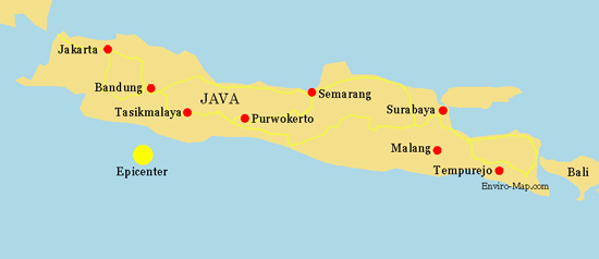
Java, Indonesia Earthquake Map 2009

java_earthquake2009

On September 2nd a large earthquake hit the southern coast of the island of Java. It was measured at an intensity of 7.3 and has left thousands of homes damaged and at least 40 people dead so far.

The town worst affected by the earthquake is Tasikmalaya, shown in the map above. Tremors could be felt as far as Jakarta in the west and Bali island in the east.

In the capital Jakarta high rise buildings swayed and suffered structural damage. People evacuated buildings and gathered in open spaces as aftershocks continued.

There were also fears of a tsunami and an alert was raised but it has been retracted.
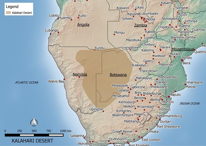
Karahari Desert Map

KALAHARI DESERT MAP

This is a map of the Kalahari desert that I made. If you’d like to use it on your site, please let me know by emailing me @ kaotic_ken(at)yahoo.com.

The Karahari desert is located in Botswana and parts of South Africa and Namibia. The total area is estimated to be about 260,000 sq km large and is part of a larger Kalahari Basin. The desert is generally flat with an elevation of about 1000 meters above sea level.

The Kalahari is semi-arid with droughts occuring frequently. The regions receives an average of 200 milimeters of precipitation a year mainly between October and May. The temperature can reach as high as 45 degrees celcius in summer and as low as below freezing in winter.

Made with Natural Earth. Free vector and raster map data @ naturalearthdata.com.

Victoria Australia Bushfire Map 2009

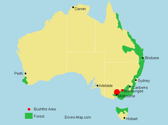
Victoria bushfire map

The map above shows the approximate areas in Victoria affected by bushfire in February 2009. Authorities believe the fires were lit deliberately and are currently searching for the arsonists. The death toll in Victoria is expected to run into the hundreds. The major areas affected are located around Melbourne especially the towns of Marysville, Buxton and Narbethong. Residents have lost their houses, livestock and their livelhoods.

Salar de Uyuni Bolivia’s Salt Desert

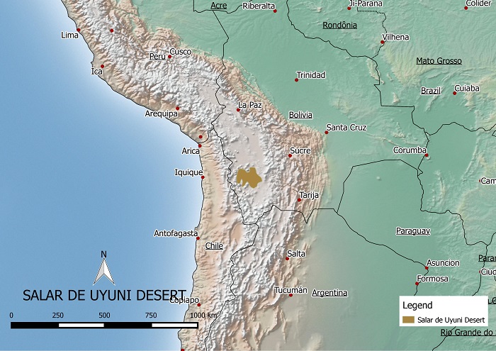
Salar de Uyuni in Bolivia map

The Saral de Uyuni located in Bolivia is the worlds largest salt flat. It is located in the southwest of Bolivia and is about 10,582 km². The salt flat used to be part of a large prehistoric lake named Lake Minchin that existed approximately 40,000 years ago.

Annually 25,000 tons of salt is extracted from the region. Lithium reserves can also be found in the region, but so far there are no mining sites. Other important uses for the region include tourism and the breeding of South American flamingos.


Major Australian Deserts

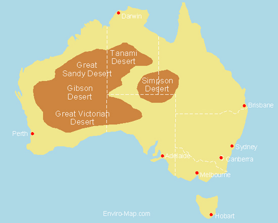
Australian Desert Map

The five largest deserts in Australia include the Great Victoria Desert: 424,400 km2, Great Sandy Desert: 284,993 km2, Tanami Desert: 184,500 km2, Simpson Desert: 176,500 km2, and the Gibson Desert: 156,000 km2.

The map above shows the general location of the five major deserts. A recent trend has been an increase in rainfall in these arid areas. For example some parts of the Gibson desert have doubled in rainfall from an average of 150 mm to 300 mm annually.

Along with this increase in rainfall in the desert regions, there has been a decrease in southern areas. Scientists say that this is the result of north-west cloud bands that used to bring rain to southern regions, moving north over central Australia.


http://www.worldatlas.com/webimage/countrys/oceania/aussnewld.htm

http://www.outback-australia-travel-secrets.com/australian-desert.html

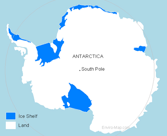
Map of Antarctica

Map of Antarctica

Here is a map of Antarctica I designed showing the land and ice shelves.

Antarctica is the fifth-largest continent in the world and is about 14.4 million square kilometers in size. 98 percent of the continent is covered by ice.

Ice shelves are formed around the continent where ice, which was formed on the land, moved off the land and is floating on the sea.

The ice on and around Antarctica has been speculated to be unaffected by climate change or global warming. There has been no evidence to suggest that melting Antarctic ice has contributed to a rise in sea level.

Another environmental characteristic is a large hole in the ozone layer above Antarctica. It is still increasing in size but it has no effect on the continent’s environment.

http://en.wikipedia.org/wiki/Antarctica#Effects_of_global_warming

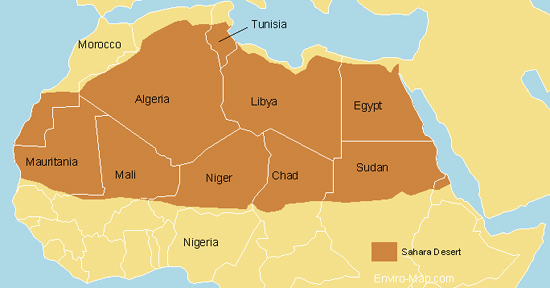
Sahara Desert Map

Sahara Desert Map

Purchase an image of this map at higher resolution for only $2.


Here is a map of the Sahara desert that I designed.

The Sahara desert is estimated to be about 9,000,000 square kilometers. It is bigger than the total area of Australia and almost as large as continental United States.

It encompasses Algeria, Chad, Egypt, Libya, Mali, Mauritania, Morocco, Niger, Western Sahara, Sudan and Tunisia.

There has been speculation that the Sahara is expanding and encroaching on the Sub-Saharan region however these claims have not been proven.

Vegetation measurements taken from satellite images showed that over 11 years the Sahara ebbs and flows much like a tide and hasn’t been continually expanding.

Source:

http://findarticles.com/p/articles/mi_m1200/is_n3_v140/ai_11127602

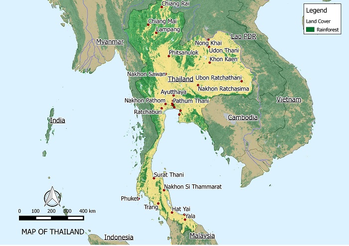
Rainforest in Thailand

RAINFOREST IN THAILAND MAP zoomed 700

In 1945, 61 percent of Thailand was covered by forest. This percentage dropped to 34 percent and currently about 28.4 percent of Thailand is covered by forest.

From 1990 to 2000 the rate of deforestation has been estimated at about 0.72 percent. From 2000 to 2005 deforestation had reduced to about 0.4 percent per annum.

The main driver of deforestation in Thailand is the rapid increase in population. This increase is most evident in the north eastern region where the forest is cleared for farming to feed the nation’s growing population.

The Government of Thailand has encouraged reforestation programs and had put in place a ban on all commercial logging in 1989.

Source:

http://rainforests.mongabay.com/deforestation/2000/Thailand.htm

http://en.wikipedia.org/wiki/Deforestation_in_Thailand

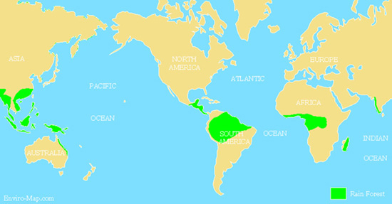
The World’s Tropical Rainforest

World's Tropical Rainforest Map

The world’s tropical rain forest is located in South and Central America, Africa, Asia and Australia. It is the home for about half of all animal and plant species in the world. Also over a quarter of all modern medicine come from plants found in this type of forest. It is often called “the world’s largest pharmacy”. Vast amounts of the worlds carbon dioxide is stored in these forests. Therefore deforestation would lead to the release of this carbon into the atmosphere accelerating global warming.
Continue reading The World’s Tropical Rainforest