Amazon Tribe Embraces Web Mapping

With the recent boom of web mapping, such as Google Map and Google Earth, the general public has enjoyed the convenience of free spatial data at their finger tips. Now even the most isolated of people are being drawn to the benefits of internet mapping.

As have the Surui tribe from the Rondonia region of the Amazon in Brazil. Though their cause is more crucial than the average Joe who uses Google Earth to find the location of a restaurant or to bring up a birds eye view of the house they live in.

Continue reading Amazon Tribe Embraces Web Mapping

The Boreal Forest – Canada

The Boreal Forest – The World’s Carbon Storehouse

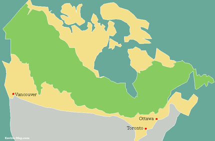
Canada’s Boreal forest (depicted in green in the map below) is part of the larger Biome called the “Taiga”. The Taiga covers the northern areas of the Arctic tree line. Canada’s Boreal forest in particular is considered the largest carbon storehouse in the world. It houses 22 percent of the the carbon stored in the world’s land surface. The Boreal stores twice as much carbon per unit area compared to tropical forests. This is due to the cold temperatures which preserve the soils resulting in deep organic soils that are thousands of years old.

 The Threat to the Boreal Forest
Global warming and deforestation have threatened to release large amounts of carbon from the Boreal forest. 90 percent of all of Canada’s carbon is stored in the Boreal region. It is estimated that 186 billion tons of carbon is stored in the soil therefore destruction of the forest would greatly accelerate global warming. In response to this threat the Canadian Government implemented a plan to protect 25 million acres of Boreal land in November 2007.Boreal Forest Map

Reference

http://www.cpaws.org/

China’s Gobi Desert

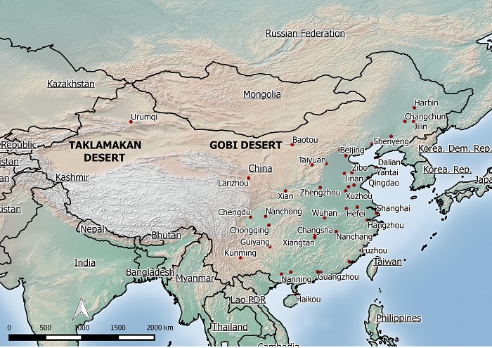
Map of China’s Desert
China's Gobi and Taklamakan deserts
China’s desert area is increasing at an alarming rate. The Gobi desert has increased in size by 25,000 square miles since 1994 and it’s sands have encroached as far as 100 miles from Beijing, the host city of the 2008 Olympic games.
The dust from the desert contributes to poor visibility and health problems such as respiratory and skin disorders. Moreover the desertification reduces the amount of arable land and therefore affects China’s ability to produce grains to feed its population. Official reports say that about 4000 villages across China have been swallowed up by the encroaching desert and it has affected more than 200 million people.
Not only has the sands affected Chinese people but the sands are blown to nearby countries like Korea and Japan and even as far as the West coast of North America. The main causes of the desertification are a persistent drought, overgrazing, indiscriminate use of ground water and rampant logging. The government has been trying hard to fight the desertification by planting trees around the desert’s periphery, hoping to contain its expansion.

Reference:
http://www.inthesetimes.com/article/2849/

Made with Natural Earth. Free vector and raster map data @ naturalearthdata.com.

Amazon Rainforest Map

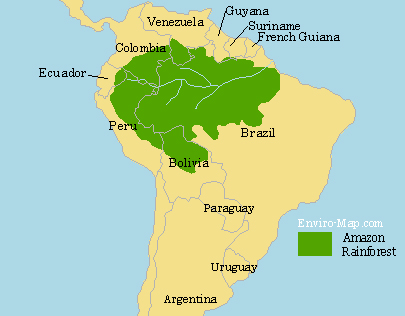
Map of the Amazon Rainforest
amazon_forest

The Extent of the Rainforest

The Amazon Rainforest is about 5.5 Million square kilometers and it represents over half of the planets remaining rainforests. It is estimated that about 587,000 square kilometers of the Amazon has been deforested since the colonization by the Europeans. The deforested land is primarily used for raising cattle and farming soybeans. The map above shows the current extent of the Amazon.

The Importance of the Amazon Rainforest

The Amazon represents over half of the world’s rainforest and it is the most species rich biome in the world. It is estimated that one third of all species live in the Amazon. There are still many more plant and animal species not yet discovered. Many of these species could contain substances valuable for producing various types of medicine.

The plants in the Amazon absorb and contain carbon from the air. Therefore destruction of the rainforest would release carbon into the atmosphere, accelerating global warming. Burning of the rainforest has made Brazil one of the top greenhouse gas producers in the world.

Deforestation

From 1990 to 2003 the annual rate of deforestation had increased due to local, national and international factors. 70 percent of all the deforested land is used for raising livestock such as cattle. The remainder is primarily used for growing soybeans and sugarcane, making Brazil the second largest producer of soybeans in the world.

Another contributing factor to deforestation is the growing interest in biofuel. As the world’s fossil fuel resources are becoming more depleted, the demand for biofuel is increasing. The biofuel, ethanol is produced from sugarcane in Brazil and Brazil has the largest national ethanol fuel industries in the world.


References

http://en.wikipedia.org/wiki/Amazon_Rainforest

http://en.wikipedia.org/wiki/Ethanol
Sakhalin: the Edge of the Earth

Location:
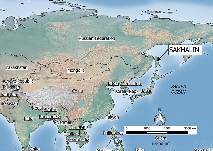
Sakhalin is an island located North of Japan in the North Pacific Ocean. It is a part of the Nation of Russia. The island and its surrounding sea is rich in oil and gas, and has become the new attraction for oil and gas companies. Two thirds of the geography of the island is considered mountainous and it has a population of nearly 700,000. Below is a map showing its location.

Sakhalin Location
Indigenous People:
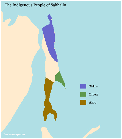
The native inhabitants of the Island are made up of three major groups. These people are called the Nivkhs, the Ainu and the Oroks. It is believed that these native people first started inhabiting this island since the last Ice age, as far back as 14500 BC. The three groups traditionally lived in separate parts of the Island. The map below shows their dispersion.

Sakhalin Tribes map
Oil and Gas Exploration:
Since the collapse of the USSR the island has experienced a resources boom. In 1996 two consortia were signed to explore for oil and gas off the north east coast of the Sakhalin. These two projects are called Sakhalin I and Sakhalin II.

Continue reading Sakhalin: the Edge of the Earth