Japan’s Mountainous Areas Map

mountainous area of japan map

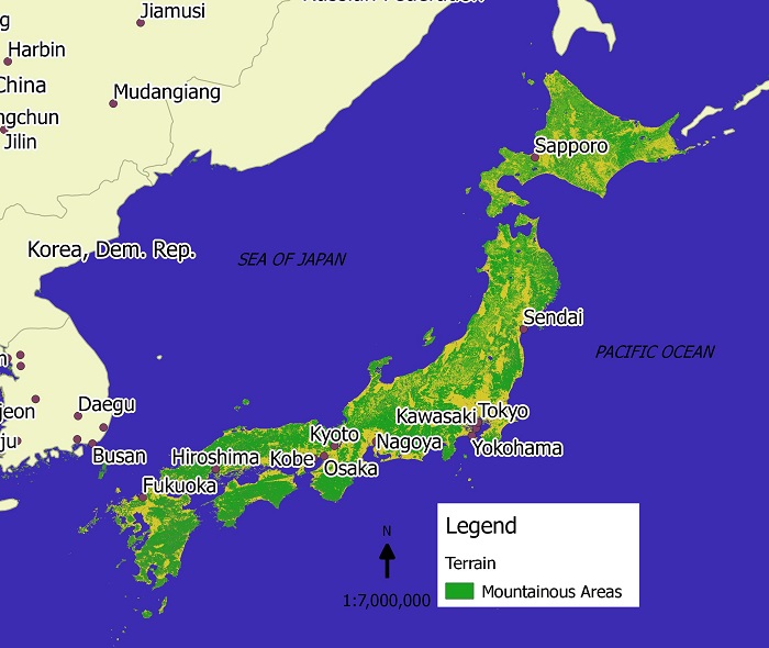
Here’s a map of Japan that I created. It shows the mountainous area of the island nation and as indicated on the map the majority of the land is mountainous and therefore difficult for residential, industrial or agricultural uses.

It is estimated to be about 145,883 square miles in size with 70 to 80% being mountainous. The mountainous areas are usually covered in forest.

Difficulties in traveling across the country have been overcome by technological advances, as Japan is famous for its long railway tunnels that go under the hills and mountains.

Because of Japan’s location at the intersection of three tectonic plates, earthquakes are commonplace. In addition to this, 10% of the world’s active vocanos are found in Japan. The most famous of Japan’s volcanos is mount Fuji, located between Tokyo and Shizuoka, which is still considered active. In the cooler seasons, steam can be seen bellowing out of the top of Mount Fuji.

Sonoran Desert Map

Sonoran desert map

The Sonoran desert is one of the largest and hottest deserts in North America. It is about 120,000 square miles in size. Despite the harsh conditions the thriving city of Phoenix is located in this desert. Phoenix has a population of over 4 million and is one of the fastest growing cities in the US. The desert is actually losing ground to the urban sprawl around Phoenix.

The Sonoran desert is home to an assortment of cactus species including the famous saguaro cactus, pictured below, which is found only in the Sonoran. There is also a diverse range of animals including the bobcat, coyote, antelope and various reptile species.

cactus

cc photo credit: SearchNetMedia

Java, Indonesia Earthquake Map 2009

java_earthquake2009

On September 2nd a large earthquake hit the southern coast of the island of Java. It was measured at an intensity of 7.3 and has left thousands of homes damaged and at least 40 people dead so far.

The town worst affected by the earthquake is Tasikmalaya, shown in the map above. Tremors could be felt as far as Jakarta in the west and Bali island in the east.

In the capital Jakarta high rise buildings swayed and suffered structural damage. People evacuated buildings and gathered in open spaces as aftershocks continued.

There were also fears of a tsunami and an alert was raised but it has been retracted.

Free Map of the World


Free map of the world with ocean and continents

Here’s a free map of the world that I created. It shows the names of each continent and the names of each major ocean. It does not show the borders of countries.

Please feel free to use it on your websites. However I’d appreciate it if you would have a link back to this page and state “Map produced by Enviro-Map.com”.

GIS data:

Made with Natural Earth. Free vector and raster map data @ naturalearthdata.com.

Karahari Desert Map

KALAHARI DESERT MAP

This is a map of the Kalahari desert that I made. If you’d like to use it on your site, please let me know by emailing me @ kaotic_ken(at)yahoo.com.

The Karahari desert is located in Botswana and parts of South Africa and Namibia. The total area is estimated to be about 260,000 sq km large and is part of a larger Kalahari Basin. The desert is generally flat with an elevation of about 1000 meters above sea level.

The Kalahari is semi-arid with droughts occuring frequently. The regions receives an average of 200 milimeters of precipitation a year mainly between October and May. The temperature can reach as high as 45 degrees celcius in summer and as low as below freezing in winter.

Made with Natural Earth. Free vector and raster map data @ naturalearthdata.com.

Victoria Australia Bushfire Map 2009

Victoria bushfire map

The map above shows the approximate areas in Victoria affected by bushfire in February 2009. Authorities believe the fires were lit deliberately and are currently searching for the arsonists. The death toll in Victoria is expected to run into the hundreds. The major areas affected are located around Melbourne especially the towns of Marysville, Buxton and Narbethong. Residents have lost their houses, livestock and their livelhoods.

Salar de Uyuni Bolivia’s Salt Desert

Salar de Uyuni in Bolivia map

The Saral de Uyuni located in Bolivia is the worlds largest salt flat. It is located in the southwest of Bolivia and is about 10,582 km². The salt flat used to be part of a large prehistoric lake named Lake Minchin that existed approximately 40,000 years ago.

Annually 25,000 tons of salt is extracted from the region. Lithium reserves can also be found in the region, but so far there are no mining sites. Other important uses for the region include tourism and the breeding of South American flamingos.


Major Australian Deserts

Australian Desert Map

The five largest deserts in Australia include the Great Victoria Desert: 424,400 km2, Great Sandy Desert: 284,993 km2, Tanami Desert: 184,500 km2, Simpson Desert: 176,500 km2, and the Gibson Desert: 156,000 km2.

The map above shows the general location of the five major deserts. A recent trend has been an increase in rainfall in these arid areas. For example some parts of the Gibson desert have doubled in rainfall from an average of 150 mm to 300 mm annually.

Along with this increase in rainfall in the desert regions, there has been a decrease in southern areas. Scientists say that this is the result of north-west cloud bands that used to bring rain to southern regions, moving north over central Australia.


http://www.worldatlas.com/webimage/countrys/oceania/aussnewld.htm

http://www.outback-australia-travel-secrets.com/australian-desert.html

Map of Antarctica

Map of Antarctica

Here is a map of Antarctica I designed showing the land and ice shelves.

Antarctica is the fifth-largest continent in the world and is about 14.4 million square kilometers in size. 98 percent of the continent is covered by ice.

Ice shelves are formed around the continent where ice, which was formed on the land, moved off the land and is floating on the sea.

The ice on and around Antarctica has been speculated to be unaffected by climate change or global warming. There has been no evidence to suggest that melting Antarctic ice has contributed to a rise in sea level.

Another environmental characteristic is a large hole in the ozone layer above Antarctica. It is still increasing in size but it has no effect on the continent’s environment.

http://en.wikipedia.org/wiki/Antarctica#Effects_of_global_warming