Sahara Desert Map

Sahara Desert Map

Purchase an image of this map at higher resolution for only $2.


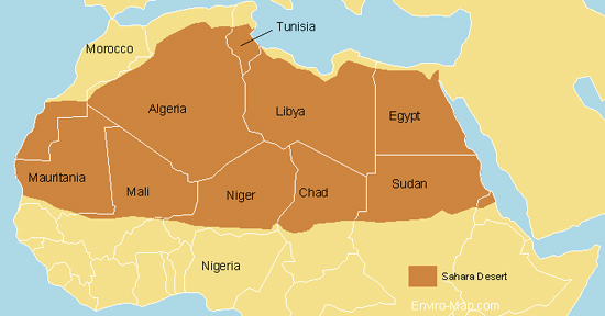
Here is a map of the Sahara desert that I designed.

The Sahara desert is estimated to be about 9,000,000 square kilometers. It is bigger than the total area of Australia and almost as large as continental United States.

It encompasses Algeria, Chad, Egypt, Libya, Mali, Mauritania, Morocco, Niger, Western Sahara, Sudan and Tunisia.

There has been speculation that the Sahara is expanding and encroaching on the Sub-Saharan region however these claims have not been proven.

Vegetation measurements taken from satellite images showed that over 11 years the Sahara ebbs and flows much like a tide and hasn’t been continually expanding.

Source:

http://findarticles.com/p/articles/mi_m1200/is_n3_v140/ai_11127602
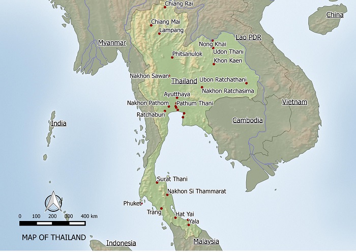
Rainforest in Thailand

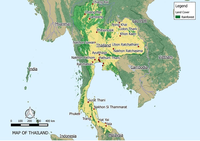
RAINFOREST IN THAILAND MAP zoomed 700

In 1945, 61 percent of Thailand was covered by forest. This percentage dropped to 34 percent and currently about 28.4 percent of Thailand is covered by forest.

From 1990 to 2000 the rate of deforestation has been estimated at about 0.72 percent. From 2000 to 2005 deforestation had reduced to about 0.4 percent per annum.

The main driver of deforestation in Thailand is the rapid increase in population. This increase is most evident in the north eastern region where the forest is cleared for farming to feed the nation’s growing population.

The Government of Thailand has encouraged reforestation programs and had put in place a ban on all commercial logging in 1989.

Source:

http://rainforests.mongabay.com/deforestation/2000/Thailand.htm

http://en.wikipedia.org/wiki/Deforestation_in_Thailand

The World’s Tropical Rainforest

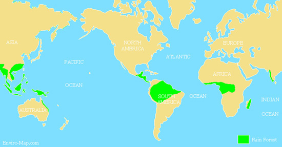
World's Tropical Rainforest Map

The world’s tropical rain forest is located in South and Central America, Africa, Asia and Australia. It is the home for about half of all animal and plant species in the world. Also over a quarter of all modern medicine come from plants found in this type of forest. It is often called “the world’s largest pharmacy”. Vast amounts of the worlds carbon dioxide is stored in these forests. Therefore deforestation would lead to the release of this carbon into the atmosphere accelerating global warming.
Continue reading The World’s Tropical Rainforest

Amazon Tribe Embraces Web Mapping

With the recent boom of web mapping, such as Google Map and Google Earth, the general public has enjoyed the convenience of free spatial data at their finger tips. Now even the most isolated of people are being drawn to the benefits of internet mapping.

As have the Surui tribe from the Rondonia region of the Amazon in Brazil. Though their cause is more crucial than the average Joe who uses Google Earth to find the location of a restaurant or to bring up a birds eye view of the house they live in.

Continue reading Amazon Tribe Embraces Web Mapping

The Boreal Forest – Canada

The Boreal Forest – The World’s Carbon Storehouse

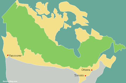
Canada’s Boreal forest (depicted in green in the map below) is part of the larger Biome called the “Taiga”. The Taiga covers the northern areas of the Arctic tree line. Canada’s Boreal forest in particular is considered the largest carbon storehouse in the world. It houses 22 percent of the the carbon stored in the world’s land surface. The Boreal stores twice as much carbon per unit area compared to tropical forests. This is due to the cold temperatures which preserve the soils resulting in deep organic soils that are thousands of years old.

 The Threat to the Boreal Forest
Global warming and deforestation have threatened to release large amounts of carbon from the Boreal forest. 90 percent of all of Canada’s carbon is stored in the Boreal region. It is estimated that 186 billion tons of carbon is stored in the soil therefore destruction of the forest would greatly accelerate global warming. In response to this threat the Canadian Government implemented a plan to protect 25 million acres of Boreal land in November 2007.Boreal Forest Map

Reference

http://www.cpaws.org/