Sonoran Desert Map

Sonoran desert map

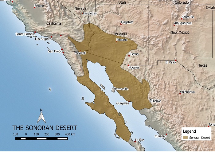
The Sonoran desert is one of the largest and hottest deserts in North America. It is about 120,000 square miles in size. Despite the harsh conditions the thriving city of Phoenix is located in this desert. Phoenix has a population of over 4 million and is one of the fastest growing cities in the US. The desert is actually losing ground to the urban sprawl around Phoenix.

The Sonoran desert is home to an assortment of cactus species including the famous saguaro cactus, pictured below, which is found only in the Sonoran. There is also a diverse range of animals including the bobcat, coyote, antelope and various reptile species.

cactus

cc photo credit: SearchNetMedia

Karahari Desert Map

KALAHARI DESERT MAP

This is a map of the Kalahari desert that I made. If you’d like to use it on your site, please let me know by emailing me @ kaotic_ken(at)yahoo.com.

The Karahari desert is located in Botswana and parts of South Africa and Namibia. The total area is estimated to be about 260,000 sq km large and is part of a larger Kalahari Basin. The desert is generally flat with an elevation of about 1000 meters above sea level.

The Kalahari is semi-arid with droughts occuring frequently. The regions receives an average of 200 milimeters of precipitation a year mainly between October and May. The temperature can reach as high as 45 degrees celcius in summer and as low as below freezing in winter.

Made with Natural Earth. Free vector and raster map data @ naturalearthdata.com.

Sahara Desert Map

Sahara Desert Map

Purchase an image of this map at higher resolution for only $2.


Here is a map of the Sahara desert that I designed.

The Sahara desert is estimated to be about 9,000,000 square kilometers. It is bigger than the total area of Australia and almost as large as continental United States.

It encompasses Algeria, Chad, Egypt, Libya, Mali, Mauritania, Morocco, Niger, Western Sahara, Sudan and Tunisia.

There has been speculation that the Sahara is expanding and encroaching on the Sub-Saharan region however these claims have not been proven.

Vegetation measurements taken from satellite images showed that over 11 years the Sahara ebbs and flows much like a tide and hasn’t been continually expanding.

Source:

http://findarticles.com/p/articles/mi_m1200/is_n3_v140/ai_11127602

China’s Gobi Desert

Map of China’s Desert
China's Gobi and Taklamakan deserts
China’s desert area is increasing at an alarming rate. The Gobi desert has increased in size by 25,000 square miles since 1994 and it’s sands have encroached as far as 100 miles from Beijing, the host city of the 2008 Olympic games.
The dust from the desert contributes to poor visibility and health problems such as respiratory and skin disorders. Moreover the desertification reduces the amount of arable land and therefore affects China’s ability to produce grains to feed its population. Official reports say that about 4000 villages across China have been swallowed up by the encroaching desert and it has affected more than 200 million people.
Not only has the sands affected Chinese people but the sands are blown to nearby countries like Korea and Japan and even as far as the West coast of North America. The main causes of the desertification are a persistent drought, overgrazing, indiscriminate use of ground water and rampant logging. The government has been trying hard to fight the desertification by planting trees around the desert’s periphery, hoping to contain its expansion.

Reference:
http://www.inthesetimes.com/article/2849/

Made with Natural Earth. Free vector and raster map data @ naturalearthdata.com.